Field note
Dicksonia on the Murringo trail, Río Verde de los Montes, Sonsón
A tree fern barely documented in eastern Antioquia grows on the Murringo trail, at the foot of the Sonsón páramo; to the north, toward La Honda, I have not found it.
The revision of Neotropical Dicksonia by Noben et al. (2018) redefined the circumscription of the species of this tree fern genus and, with it, which of them grow in Colombia. For the country it recognizes Dicksonia karsteniana (Klotzsch) T.Moore, with the varieties karsteniana and arachneosa; D. navarrensis Christ; D. lehnertiana, described in the same revision and known from northern Antioquia; and D. stuebelii, with a single Colombian specimen, collected in 1945 (Noben et al., 2018: 847–855). The name D. sellowiana Hook., which most Colombian Dicksonia records in GBIF still carry, is restricted to the Mata Atlântica of south-eastern Brazil and adjacent Paraguay, Argentina and Uruguay (Noben et al., 2018: 841, 854; GBIF.org, 2026a).
I found no herbarium specimen of Dicksonia from Sonsón, and only one determined as such from the rest of eastern Antioquia. There is none in GBIF, among the specimens cited by Noben et al. (2018), in the Red Book of Colombian tree ferns (Cárdenas et al., 2019), or in the database of the HUA herbarium, whose 147 Dicksonia records, from 59 collections, include none from eastern Antioquia (GBIF.org, 2026a; HUA, 2026). I found that single sheet in the HVAA portal. It is a pinna collected in 1999 at Abejorral, vereda El Buey, finca El Recreo, at 2,500 m, inside montane forest (A. Gil et al. 376, JAUM 67933; HVAA, 2026).
iNaturalist holds 25 observations of Dicksonia or Dicksoniaceae, excluding Lophosoria, from eastern Antioquia: the 24 identified to species carry the name “D. sellowiana”, and most show scales rather than hairs (iNaturalist, 2026). Dicksonia sellowiana does not grow in Colombia. In this set, therefore, most identifications are wrong. This is not carelessness on the part of the observers. Most Colombian Dicksonia records in GBIF still carry that name, and tree ferns need many characters to be identified with certainty: the habit, the shape of the frond, the number of pinnae, the type of scales or hairs from the petiole to the pinnules, the type of petiole scurf, the shape of the pinnae and pinnules, the shape of the sori, the type of indusium (sphaeropteroid, cyatheoid or others) and the length of the paraphyses, the hairs inside the sorus. There are exceptions, such as the Pueblo Rico observation I discuss below (Figure 6), in which the structures that allow an unequivocal identification were recorded. The 2014 surveys of the Sonsón páramo complex, made almost entirely above 2,800 m, recorded Lophosoria quadripinnata as the only Dicksoniaceae (Alzate & Sarrazola, 2025). A 2016 CORNARE inventory in vereda El Popal, in Río Verde de los Henaos, at 1,930–2,049 m, recorded tree ferns of the family Cyatheaceae but no Dicksoniaceae (García Morera et al., 2018).
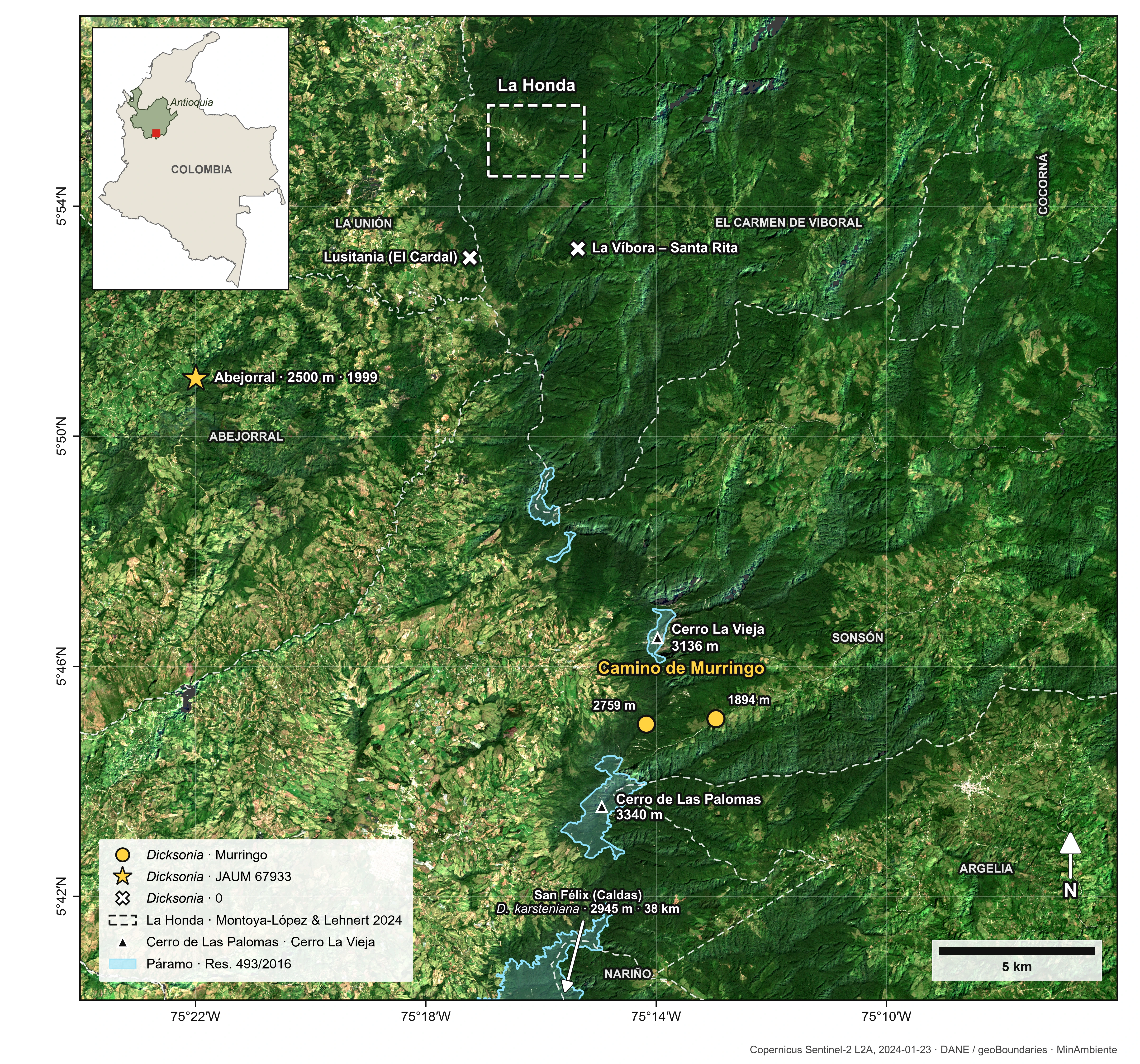
In this note I report Dicksonia on the Murringo trail, corregimiento Río Verde de los Montes, Sonsón, between 1,894 and 2,759 m, on the Magdalena slope of the Central Cordillera, on the north-eastern flank of Cerro de Las Palomas, between 3 and 4.6 km from its summit (Figure 1). I compared the material photographed near the viewpoint with two reference specimens from Antioquia and with photos of a D. navarrensis plant from Pueblo Rico (Risaralda), in the Chocó region, and tentatively identified it as D. cf. navarrensis. I also record that I have not found it to the north, toward La Honda.
The Murringo trail
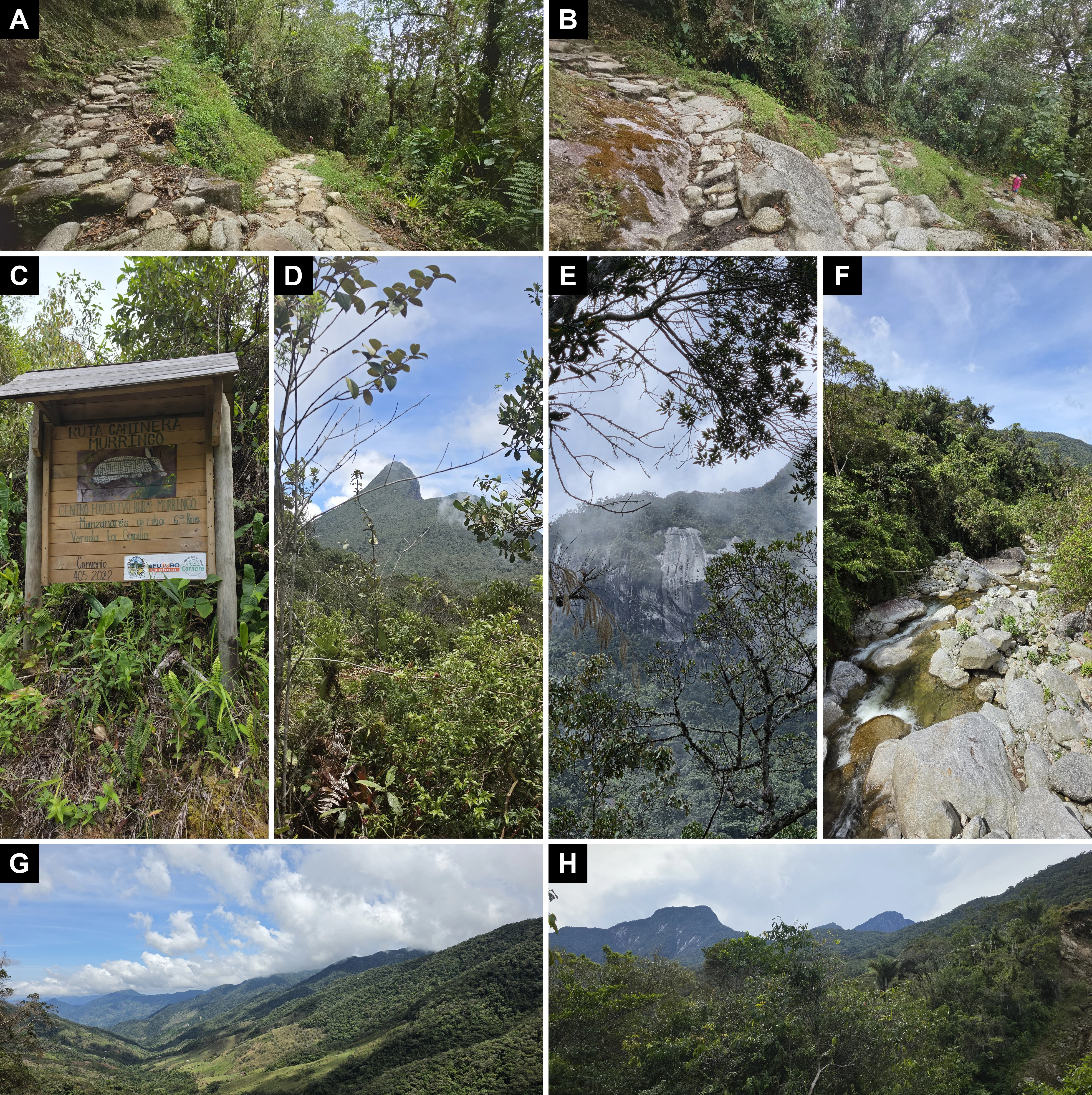
In the early twentieth century the Montes and Loaiza families, peasants from the altiplano, opened tracks from the place called La Palmita, at the foot of the páramo, and one of them became the present-day Río Verde de los Montes trail (Arroyave Arrubla, 2017: 59–60).
Between 1950 and 1980, muleteers carried maize and beans along it to Sonsón. The route from Santa Rosa, with rest stops at La Soledad, La Capilla, Murringo and La Palmita, passed through the gap of the Sonsón páramo, and each round trip took about a week (Arroyave Arrubla, 2017: 74–75). In those decades mules replaced oxen, the trails were improved with stone paving and log corduroy, and the Murringo trail left the Río Arriba sector to reach La Bodega, in vereda Manzanares, by a shorter route (Arroyave Arrubla, 2017: 75). Around the same time, the trail to Argelia, a closer town, was opened through communal work parties, and trade gradually shifted there (Jiménez Gómez, 2017: 187–189; Arroyave Arrubla, 2017: 54).
In the stretch where I made the observations, the trail descends from a viewpoint at 2,759 m, 3.0 km north-northeast of the summit of Cerro de Las Palomas, to a bridge over the Río Verde at 1,894 m (Figures 1 and 2). In a straight line the two points are 2.2 km apart, with an 865 m difference in elevation. The viewpoint lies within the Distrito Regional de Manejo Integrado (DRMI) Páramo de Vida Maitamá–Sonsón, declared by CORNARE in 2019 through Acuerdo 388, 1.1 km from its boundary. The bridge lies practically on the boundary, right where it reaches the Río Verde de los Montes (CORNARE, 2019; PNNC, 2026).
Record
New record. COLOMBIA — Antioquia • Sonsón, corregimiento Río Verde de los Montes, Murringo trail, between the viewpoint and the bridge over the Río Verde; viewpoint, 05°44.994′N, 075°14.171′W, 2,759 m a.s.l. (GPS); bridge, 05°45.091′N, 075°12.965′W, 1,894 m a.s.l. (Copernicus GLO-30 model); 29 Sep. 2026; A. Montoya-López obs.; photographic record, no herbarium specimens deposited.
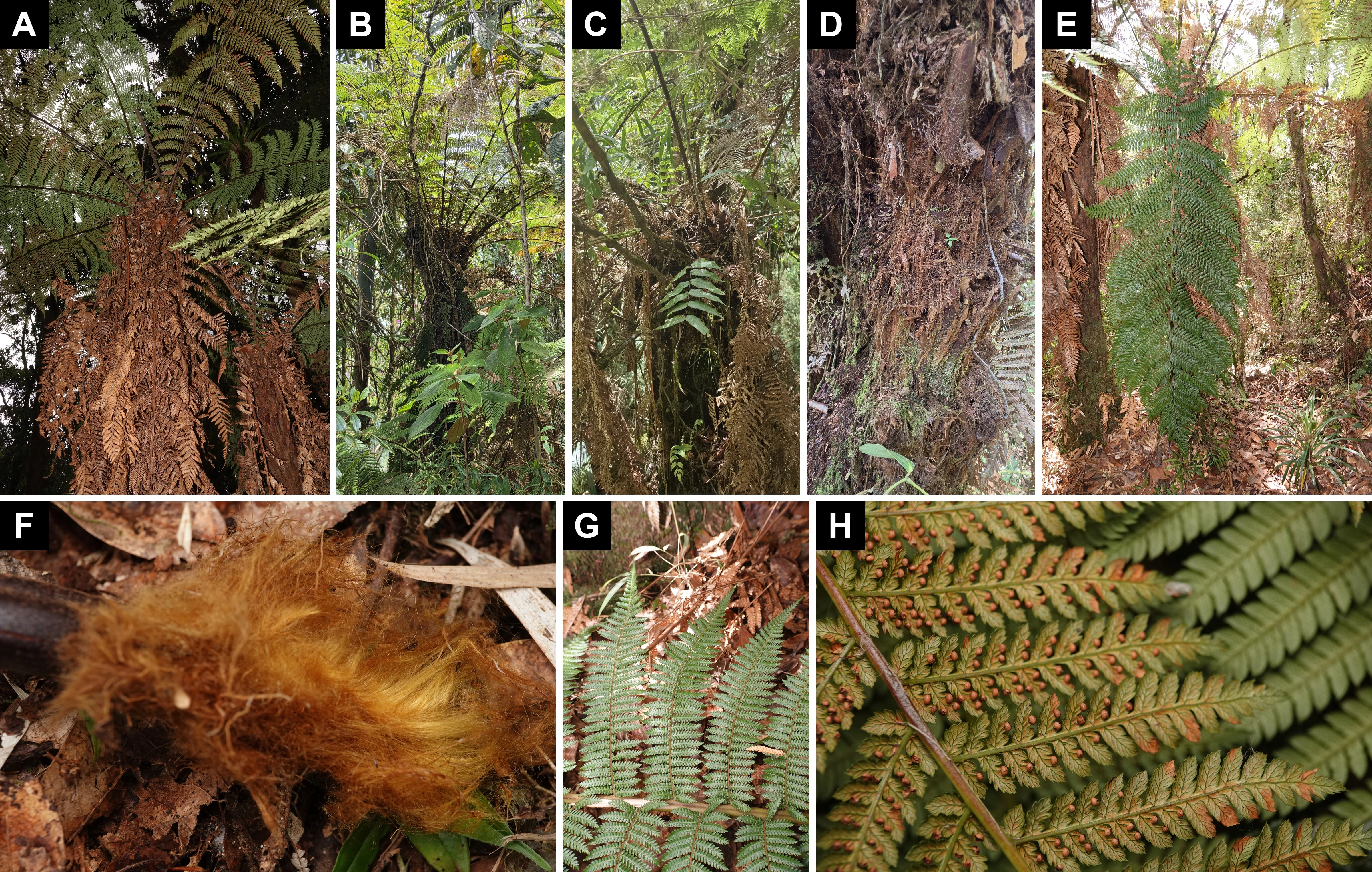
I saw Dicksonia along the whole trail, between the viewpoint and the bridge. They are tree ferns with a skirt of dead fronds that hides the trunk in some plants (Figure 3A; see also B and C). Hairs without scales at the petiole base and marginal sori at the vein tips are characters of Dicksonia (Noben et al., 2018: 839; Cárdenas et al., 2019: 17–18). Lophosoria quadripinnata, the other Dicksoniaceae in the region, forms no trunk and has no indusium (Montoya-López & Lehnert, 2024).
Identification
Noben et al. (2018: 841) separate the species mainly by the type of petiole hairs, the length of the petiole in fertile fronds, the hairiness of the rachis abaxially, the extent of hairs on the axes and veins abaxially, and the diameter of the sori. They point out that the appearance of the hairs, the shape of the basal pinnae and adventitious buds are best observed in the field, because they may be lost during specimen processing (Noben et al., 2018: 846). The characters I could see make D. lehnertiana and D. stuebelii unlikely. On the abaxial side of the fertile pinna (Figure 3H), the segment midveins and the lamina between the veins look glabrous, whereas both species have hairs on and between the veins (Noben et al., 2018: 846, 851, 855); moreover, the plants I photographed retain a dense skirt of dead fronds (Figure 3A, C), which D. lehnertiana and D. stuebelii usually do not form (Noben et al., 2018: 841). Dicksonia stuebelii has linear pinnules with rounded segments (Noben et al., 2018: 846, 855), whereas the Murringo pinnules are pinnatifid with serrate segments (Figure 3G). Dicksonia lehnertiana has spreading, bristly hairs with indurated bases (Noben et al., 2018: 846, 851), whereas those on the detached petiole base I photographed near the viewpoint are long, fine and lustrous (Figure 3F). Dicksonia sellowiana is excluded by its distribution (Noben et al., 2018: 841). That leaves D. karsteniana and D. navarrensis, which the key separates in its last couplet.
Dicksonia navarrensis has the outer petiole hairs tangled and matted, thin-walled. Only from Panama to Ecuador may it bear adventitious buds at the petiole bases, instead of the basal 1–2 pinna pairs, and its sori, 1.0–1.2(–1.5) mm in diameter, usually do not touch each other and leave the midvein visible. Dicksonia karsteniana has the outer hairs spreading and turgid, never bears buds at the petiole base, and its sori, (1.2–)1.5–2.0 mm in diameter, usually touch each other and often hide the midvein; mature ones often cover the segment abaxially (Noben et al., 2018: 846).
The authors also give the elevation ranges: 940–2,450(–2,800) m for D. navarrensis and (1,200–)1,800–3,300(–3,600) m for D. karsteniana (Noben et al., 2018: 847, 853). In Antioquia, the D. navarrensis specimens they cite range from 1,428 to 2,200 m, and those of D. karsteniana var. karsteniana from 2,550 to 2,980 m (Noben et al., 2018: 849, 853).
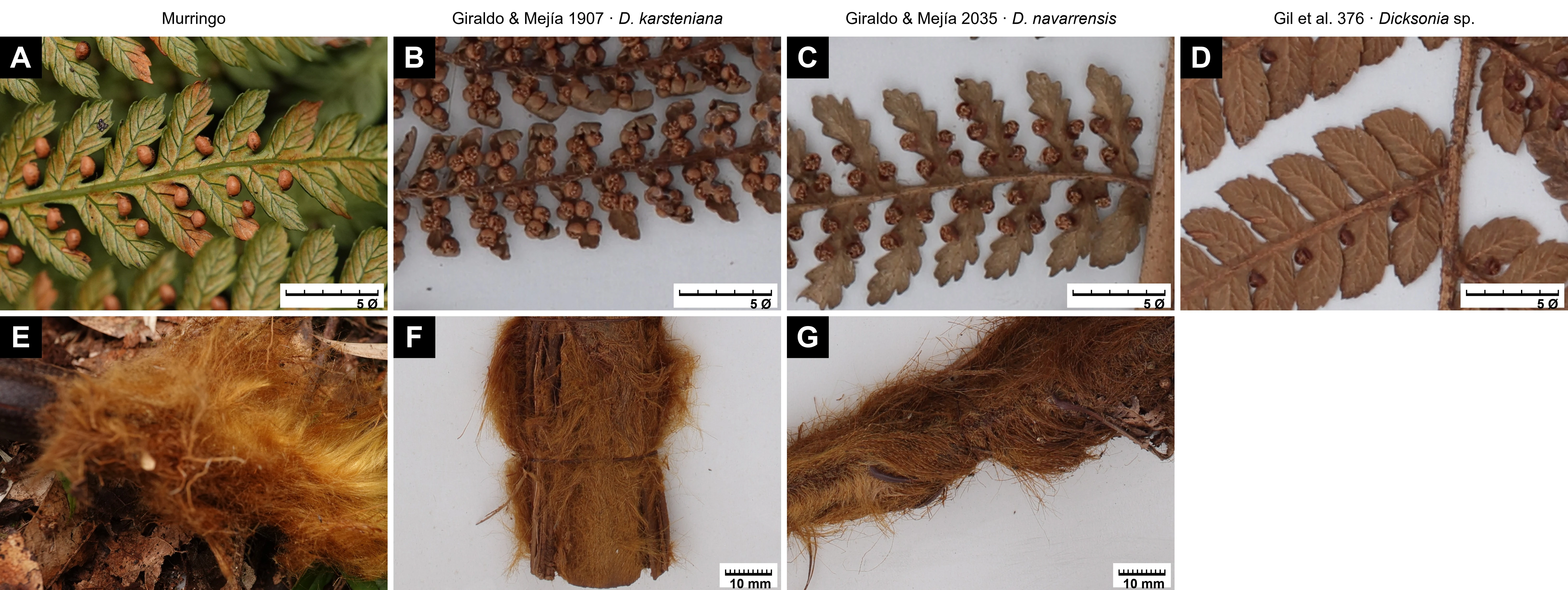
For a concrete reference, I measured the images of two specimens from Antioquia cited by Noben et al. (2018) (HVAA, 2026; Figure 4). One is D. karsteniana var. karsteniana, F. Giraldo & S. Mejía 1907 (JAUM), from Belmira, Alto del Yerbal, at 2,650 m. The other is D. navarrensis, F. Giraldo & S. Mejía 2035 (JAUM), from Amalfi, La Cascada sector, at 1,650 m. I measured each specimen in two rounds, on different sori and segments, calibrating each image against the ruler printed on the sheet, with a Python script.
In the Belmira specimen the fertile segments are contracted, and the sori touch each other and hide the midvein. In the Amalfi specimen the segments are leafy and lobed, and the paired sori are separated by a strip of lamina along which the midvein runs (Figure 4E, G). The open sori are almost the same size in both, with medians of about 1.4–1.5 mm. In the Amalfi specimen, the sori (about 1.5 mm) and their distance to the midvein (about 1.4 mm) lie at the edge of or outside the key's ranges for D. navarrensis and within those for D. karsteniana, although Noben et al. (2018) cite it as D. navarrensis; the key gives the distance to the midvein as an ambiguous character. What separates the two specimens is not the sorus diameter, which is almost the same, but the segment size (about 5 mm in the contracted Belmira specimen versus about 10 mm in the Amalfi one) and the distance from sorus to midvein (at most about 0.7 mm, versus about 1.4 mm); hence for Murringo I use ratios to the sorus diameter, which need no scale. In these two images, the colour of the hairs at the petiole base does not separate the specimens either. I corrected the white balance against the sheet paper and measured the median hue of the hairs on three crops of each petiole: it is 21–23° in the Belmira specimen and 19–25° in the Amalfi one, and both labels say “tomento leonado” (tawny tomentum). This is the colour of dried material, not that of living plants, and Noben et al. (2018: 846) do not use hair colour in the key to separate these two species. They do differ in the texture of the hair coat: dense and compact, pressed against the petiole, in the Belmira specimen, and long, loose and shaggy in the Amalfi one (Figure 4F, H).
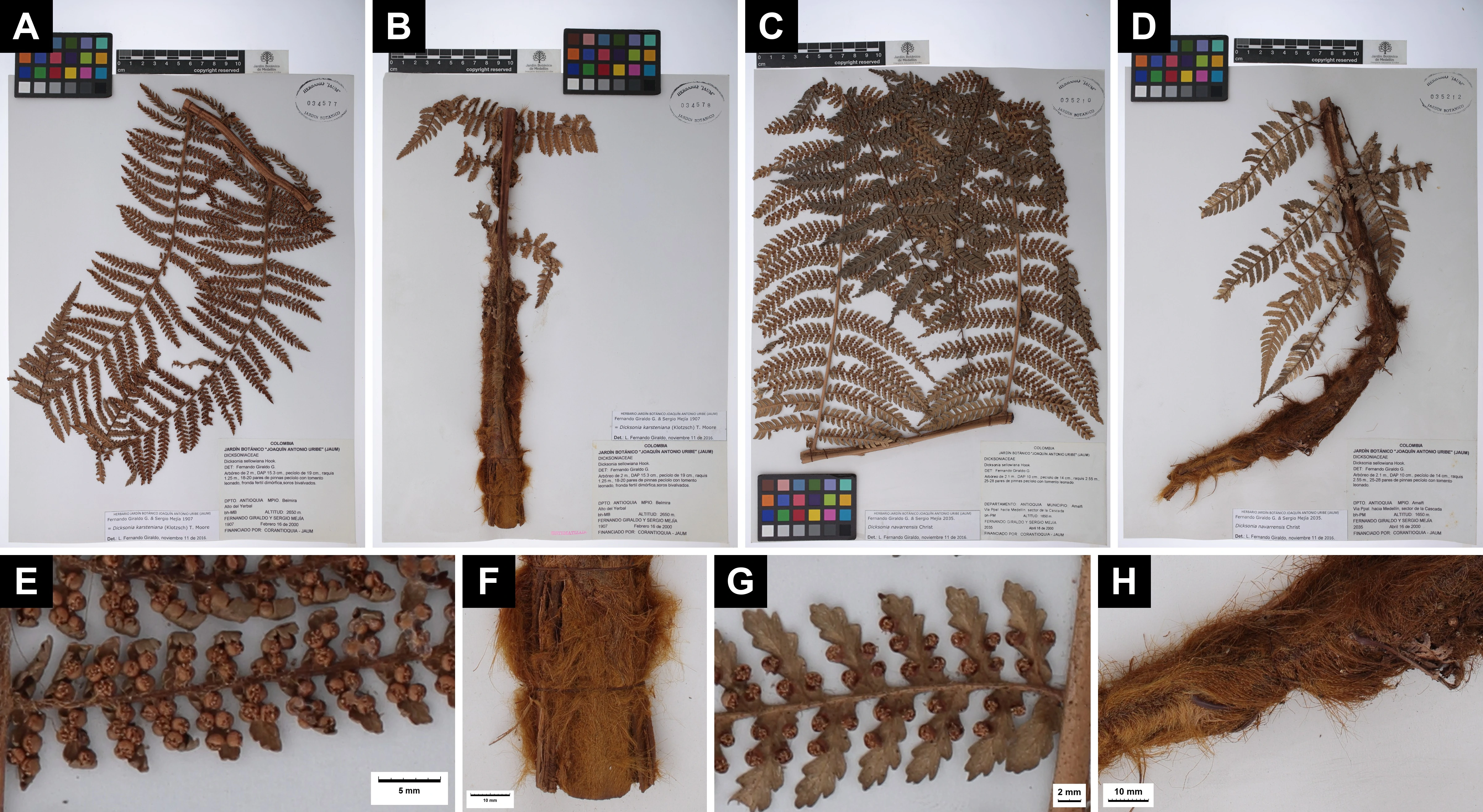
The Murringo photo of the sori has no scale, so I compared it with the two reference specimens and with the Abejorral sheet using ratios that do not depend on scale, measured on the same pinna as in Figure 3H (Figure 5A–D). In the table, values with parentheses are medians, followed by the interquartile range and the minimum–maximum; n counts sori or segments from a single pinna or a single sheet, not plants, so the table compares Murringo with those three specimens and does not measure the variation within each species.
| Character | Murringo | D. navarrensis, Giraldo & Mejía 2035 (JAUM), Amalfi | D. karsteniana, Giraldo & Mejía 1907 (JAUM), Belmira | Dicksonia sp., A. Gil et al. 376 (JAUM), Abejorral |
|---|---|---|---|---|
| Sorus diameter / distance to midvein | 0.95 (0.89–0.99; 0.73–1.42; n = 26 sori in 19 segments); on the long axis of the sorus, 1.08 (0.99–1.13; 0.82–1.55) | 1.04 (0.94–1.17; 0.64–1.47; n = 41 sori, from 23 pairs in 10 segments) | 1.96 (1.80–2.08; 1.45–2.57; n = 46 sori, from 24 pairs) | 1.00 (0.78–1.18; 0.68–1.39; n = 19 sori in 18 segments)† |
| Segment length / sorus diameter | 5.6 (5.1–6.2; 4.7–7.2; n = 11 whole segments); on the long axis of the sorus, about 5.0 | 6.6 and 7.1* | 3.4 and 3.5* | 6.2 (5.1–6.6; 4.2–7.7; n = 18 segments) |
| Fertile segment | Leafy, serrate | Leafy, lobed | Contracted | Leafy, not contracted, crenate-serrate |
| Sori per segment | 1–2 visible, 25 of 26 on the acroscopic side; not touching; midvein visible in all 19 segments | 4–6 (2–3 pairs, one on each side); not touching; midvein visible | 2–5; touching and hiding the midvein | 1 (rarely 2), basal and nearly always acroscopic; not touching; midvein uncovered |
| State of the sori | All or nearly all closed | Open | Open | Mostly open or partly open |
Note to the table. I measured all measurable sori in a single photo of the pinna in Figure 3H (Figure 5A; 26 sori in 19 segments of two pinnules) and, in the specimens, sori and segments on sheets JAUM 035210 (Amalfi) and JAUM 034577 (Belmira), in pixels on the full-resolution images, converted to millimetres with each sheet's ruler (12.51–12.55 px/mm). I measured each specimen in two rounds, on different sori and segments and with different procedures for fitting the sorus outline; the ratio of the median diameter to the median distance to the midvein was 1.03 and 1.09 in the Amalfi specimen and 1.95 and 2.00 in the Belmira one. The sorus diameter is, at Murringo, the mean of the long axis of the outline of the closed sorus, dark rim included, and its width perpendicular to that axis; in the specimens, the diameter of the circle fitted to the outer contour of the open indusial cup. I took the centre of the sorus as the receptacle; at Murringo, where the closed sori are oblong (Noben et al., 2018: 847, 852), that centre may not coincide with it. Segment length is the chord from the midline of the costule to the apex, without correcting for curvature; at Murringo I measured it only in the 11 segments seen whole. At Murringo I measured the distance to the midvein perpendicularly, from the centre of each sorus to the midvein, which I traced in all 19 segments. In the specimens the midvein cannot be made out abaxially, so I placed it between the two rows of sori and used half the distance between the centres of the two sori of each opposite pair. In the Amalfi specimen I projected it onto the perpendicular to the segment axis, which equals the mean of their two distances to the midvein if it runs between them and parallel to the axis. In the Belmira specimen I measured it in a straight line. There the sori of each pair touch over the midvein, and since the sum of the distances from two points to a straight line passing between them does not exceed the distance between the points, that half is a maximum of the mean distance to the midvein, and the ratio a minimum. At Murringo I could not use this method, because 25 of the 26 sori are on the acroscopic side of the segment; in the only opposite pair, half the distance between the centres exceeds the mean of the two distances measured to the midvein by 6.5%. In the specimens, the spread of the ratio of diameter to distance from the midvein reflects that of the pairs, not that of each sorus. *In the specimens, the ratio of segment length to sorus diameter is that of the medians of the fertile segments and of the sori in each of the two rounds; these are not ranges of observations. On the Abejorral sheet (JAUM 67933; 12.50 px/mm) I measured sori and segments in two rounds, one on each half of the pinna, and checked both against a third sample; the ratios of segment length to sorus diameter pool all three. There nearly all sori are basal and single on each segment, in the sinus, so their distance to the midvein is almost half the segment width; in the few opposite pairs it is smaller, about 1.2–1.3 mm. †For one sorus I corrected the diameter, which the outline fit had inflated (from 1.79 to 1.58 mm); without that correction the maximum would be 1.57.
The distance to the midvein was not measured in the same way at Murringo and in the specimens (see the note to the table). Moreover, the Murringo sori were all or nearly all closed and few. In the segments photographed, and in that state, they do not touch (the smallest gap between two sori is about 0.4 diameters) and their edge lies 0.2–0.9 diameters from the midvein; since nearly all are on the acroscopic side, this pinna does not show whether sori on either side would come to touch over the midvein. For the ratio of diameter to distance from the midvein to reach the Belmira median, the Murringo sori would have to measure, when open, about 2.1 times their closed diameter, and opening would lower the ratio of segment length to sorus diameter. The ratios remove scale, but not the perspective of a photo of a live pinna, shrinkage from pressing, position on the frond or maturity. The ratio of segment length to sorus diameter falls between those of the Belmira and Amalfi specimens, but the ratio of sorus diameter to distance from the midvein is close to the Amalfi and Abejorral values. With leafy segments, isolated sori and an uncovered midvein, the Murringo fertile lamina looks more like the D. navarrensis specimen than the D. karsteniana one, although the latter comes from almost the same elevation. This is a descriptive comparison with two sheets, one per species, and I treat the ratios as exploratory: they are not enough to decide the species.
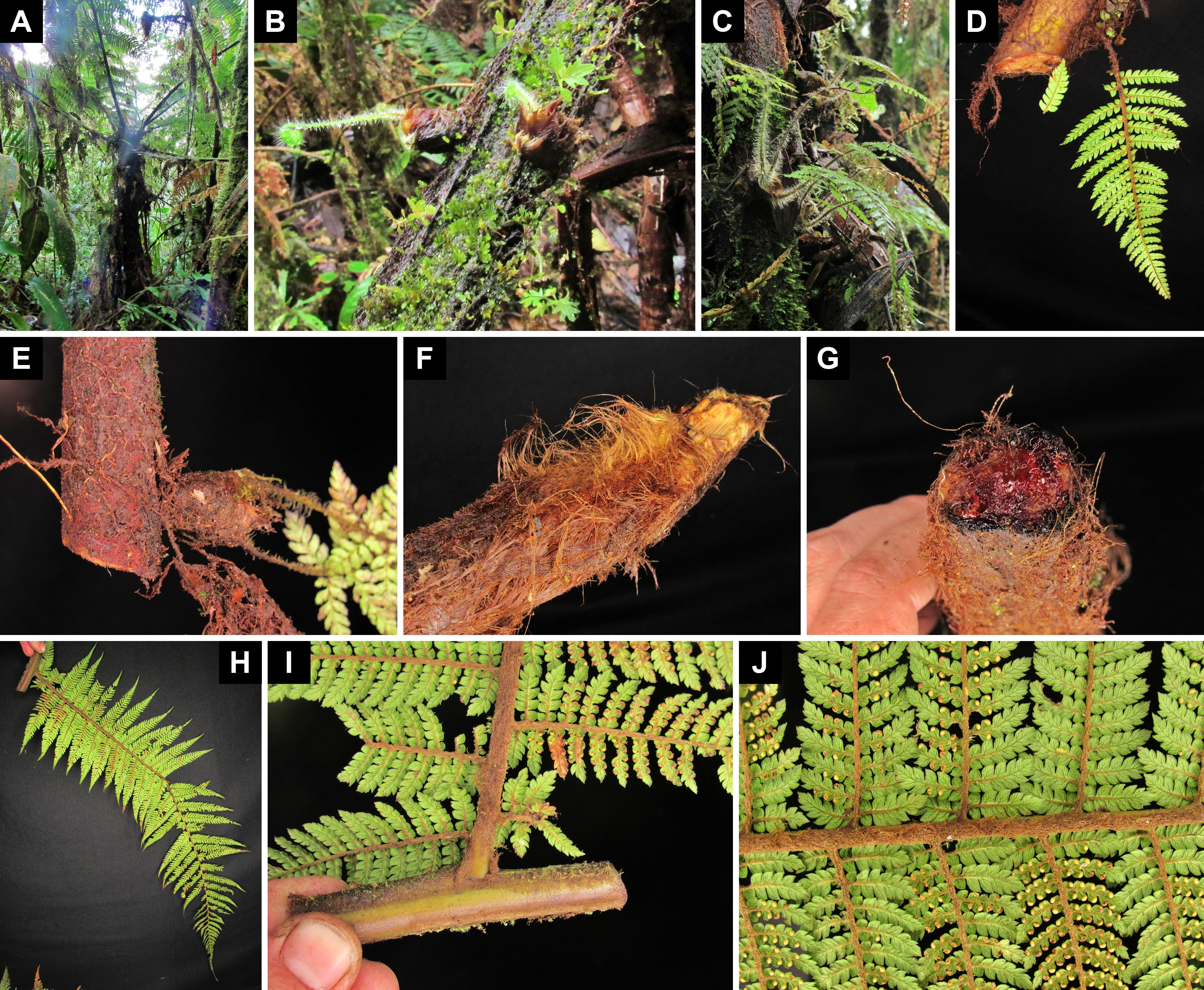
To see what the buds of D. navarrensis look like, I examined the photos of iNaturalist observation 339463561, from Pueblo Rico (Risaralda), PNN Tatamá, taken by Jonatan Castro Hernández on 5 February 2022 and linked by him to the specimen Castro-Hernández et al. 1819 (BRIT), from 2,412 m (Castro Hernández, 2022). That specimen was determined as D. navarrensis by J. Castro and A. Zuluaga in 2022, and its label reads “20 pares de pinnas, yemas prolíficas” (20 pairs of pinnae, prolific buds) (Pteridoportal, 2026). The photos show two buds covered with shiny reddish-brown tufts, one on each side of an axis, from which a young petiole and a crozier emerge (Figure 6B); a cluster of juvenile fronds sprouting from the tip of a persistent petiole base on the trunk, or beside it (Figure 6C); and young plants attached to the side of cut axes, whose point of origin is not visible (Figure 6D, E). The Pueblo Rico observation lies in the Chocó region, 0.45 km from the D. navarrensis record from Cerro Montezuma, at 2,080 m, cited by Noben et al. (2018: 853). Murringo lies on the Magdalena slope of the Central Cordillera.
Identification. I tentatively identify the material examined near the viewpoint (Figure 3A, E–H) as Dicksonia cf. navarrensis Christ. I rely on the number of pinna pairs, at least 29, and on the fertile lamina, both closer to D. navarrensis than to D. karsteniana. The main argument against it is elevation, close to the known upper limit of D. navarrensis. The hairs on the axes and the buds are not decisive. The plant is less hairy than the Pueblo Rico one and I saw no buds on it, but neither difference sets it apart from D. navarrensis, as I explain below.
First, elevation, which I take as biogeographical context rather than as a diagnostic character, because the elevation ranges of the two species overlap (Noben et al., 2018: 847, 853). According to Noben et al. (2018: 847), in Colombia D. navarrensis grows mainly west of the Western Cordillera, below 2,000 m, whereas D. karsteniana is common in the main range of the Andes, above 2,000 m. In Antioquia, however, this geographical contrast does not separate the species: almost all the Antioquia specimens of D. navarrensis they cite, including the Amalfi one, are from the Central Cordillera, and from the Western Cordillera they cite D. karsteniana, at Jardín (Noben et al., 2018: 849, 853). They also cite D. navarrensis from Palestina (Huila), at 1,970 m (Noben et al., 2018: 853). That Murringo lies on the Magdalena slope of the Central Cordillera therefore carries little weight; what counts is elevation. The material examined was photographed near the viewpoint, at about 2,750 m. That elevation lies within the usual range of D. karsteniana and is almost that of the Belmira specimen, whereas none of the Colombian D. navarrensis specimens cited by Noben et al. (2018: 853) is from above 2,200 m, and those that reach 2,450–2,800 m are from Central America. Even so, 2,750 m falls within the extreme range of D. navarrensis, up to 2,800 m (Noben et al., 2018: 853), so the argument is not decisive. In the Western Cordillera, D. navarrensis reaches 2,412 m at Pueblo Rico (Pteridoportal, 2026) and 2,345 m at El Cairo (Valle del Cauca), and there is D. karsteniana at 2,426 m at Apía (Risaralda), about 16 km from Pueblo Rico (HUA, 2026): there, the two species grow at the same elevation and close to each other. The elevation of Murringo makes D. karsteniana more likely, but it is not enough to rule out D. navarrensis.
Second, I saw no buds or plantlets at the petiole bases, and D. karsteniana never has them there, although lateral shoots may come directly from the trunk after injury (Noben et al., 2018: 846). Had I seen them, they would strongly support D. navarrensis, because they are “the most outstanding distinguishing character” of the species (Noben et al., 2018: 854). I do not, however, use their absence as an argument, because I could not assess the character properly: on the plant in Figure 3A the skirt of dead fronds hides the petiole bases attached to the trunk, which is where the buds sprout as the frond rots (Noben et al., 2018: 842, 854). Even had I assessed it, it would carry little weight. The same authors confirm the buds only from central Panama throughout the Colombian Chocó region (Noben et al., 2018: 854); in the key they restrict them to Panama–Ecuador (Noben et al., 2018: 846); and they write that the Chocó-Darién population is the only one that always has them and that north of Panama they are unknown (Noben et al., 2018: 841). Their figure 1E shows buds of a plant labelled “Dept. Caldas”, but the only D. navarrensis specimen they assign to Caldas, in appendix 1, is the one from Cerro Montezuma (Risaralda), in the Chocó region (Noben et al., 2018: 842, 853, 857). The Amalfi sheet has doubtful juvenile structures among the hairs that neither confirm nor rule out buds. I therefore do not use buds for either species. That I saw none does not set the plant apart from D. navarrensis either: outside the Chocó-Darién they are not constant (Noben et al., 2018: 841).
Third, the number of pinna pairs points toward D. navarrensis. On the hanging frond in Figure 3E I counted as a pinna only a division whose sinus reaches the rachis, with a base of its own; toward the apex, divisions that already merge into a continuous, winged blade I treated as part of the apex. By that rule I count 30 insertions on each side of the rachis, that is, at least 29 pairs. The most basal ones are harder to make out among fronds of other plants, and the base of the frond was outside the photo, so it may have had more basal pairs, or buds in their place. That figure exceeds the range of D. karsteniana, 15–20 pairs, and also that of D. navarrensis, (18–)22–26, but it is much closer to the latter (Noben et al., 2018: 847, 852). According to their labels, the Belmira specimen has 18–20 pairs and the Amalfi one 25–28 (HVAA, 2026), the closest to Murringo; the Pueblo Rico D. navarrensis has 20 (Pteridoportal, 2026), although its label does not say whether the bud positions, which replace 1–2 basal pairs, were counted (Noben et al., 2018: 846).
Fourth, the hairs on the axes are not decisive either. In the Murringo photos taken near the viewpoint, the conspicuous indumentum of long golden to ferruginous hairs is visible only on the detached petiole base (Figure 3F); on the fertile pinna (Figure 3H), abaxially, the costa shows only a fine, appressed, whitish covering, and the costules are glabrous except for a few hairs at their insertion. On the collected pinna of the Pueblo Rico D. navarrensis, by contrast, the costa is covered abaxially by a dense felt of short, fine, tangled brown hairs (Figure 6I, J), which continue along the costules to about the middle of the pinnule. The contrast is not diagnostic: the Amalfi D. navarrensis specimen does not show hairs on the costules either, the Belmira D. karsteniana specimen does have them on the costa and on the basal half of the costules, adaxially the axes arising from the horizontal axis in Figure 3G are densely pubescent, and in the key Noben et al. (2018: 846) do not use the indumentum of the axes to separate these two species. Moreover, what can be seen at Murringo matches the description of D. navarrensis: costae and costules with ciliform hairs, adaxially reddish and antrorsely curved, and abaxially pale brown to white and appressed to matted (Noben et al., 2018: 852). The Pueblo Rico plant is hairier, but that difference falls within the species. Moreover, the comparison between plants is of the abaxial surface only, of one pinna per plant or specimen, of unknown position.
The main evidence for the determination is the number of pinna pairs and the fertile lamina. In its proportions, the Murringo lamina looks more like the D. navarrensis specimen than the D. karsteniana one. But its sori were all or nearly all closed and few, so I do not know what size they reach or whether they come to touch. In the Pueblo Rico material, even the open sori remain separate from one another and leave the midvein visible (Figure 6J), as the key states for D. navarrensis (Noben et al., 2018: 846); at Murringo, with the sori closed, this cannot yet be seen. Nor is the texture of the petiole-base hairs (Figure 5E–G) reliable in photos: on a single piece of axis from Pueblo Rico, probably a petiole base, the hairs are straight and lie flat in parallel strands over most of the piece, as the key describes those of D. karsteniana in specimens “appearing plastered”, and fine, wavy and somewhat tangled toward the cut end (Figure 6F; Noben et al., 2018: 846). The Abejorral sheet, 18 km away at 2,500 m, has a similar fertile lamina: leafy, uncontracted segments, nearly always with a single basal sorus, and ratios similar to those of Murringo (sorus diameter / distance to midvein, 1.0–1.1; segment length / sorus diameter, 6.2). Its sori, however, measure 1.6–1.7 mm, above the range of D. navarrensis and within that of D. karsteniana (Noben et al., 2018: 846, 852), and its pinnules, up to 11.5 × 2.5 cm, exceed those of D. karsteniana (Noben et al., 2018: 847). These proportions alone are therefore not enough to bring a plant closer to D. navarrensis.
In short, the number of pinna pairs and the resemblance of the fertile lamina to the Amalfi specimen are the main arguments for D. navarrensis, and elevation the main one against it; none of these arguments is decisive on its own.
Remarks. There are several ways to settle this. The most direct is to look for buds on the petiole bases of several plants, recording how many are checked: the Pueblo Rico plant shows that they are easy to see in the field (Figure 6B, C). If they turned up, they would strongly support D. navarrensis; if they do not, the question remains open. The outer hairs of a petiole still attached to the plant can be examined with a hand lens, to see whether they are spreading and turgid or matted; the walls and the catenate structure of the hairs can only be seen under a microscope, on mounted hairs. The open sori of a fully fertile pinna can be photographed with a scale, to see whether the segments contract and the sori touch as in the Belmira specimen. A whole frond, with its base, would allow the number of pinna pairs to be confirmed and show whether the basal pinnae are pinnatifid with a thin costa, as in D. karsteniana, or pinnate-pinnatifid with a strong costa, as in D. navarrensis (Noben et al., 2018: 847, 852). The GPS position and elevation of each plant examined should also be recorded. The plants on the lower part of the trail, at about 1,900 m, cannot be assumed to be the same species as those photographed near the viewpoint, because both species are possible at that elevation. Above all, a herbarium voucher is needed; as far as I know, it would be the first Dicksonia specimen from Sonsón. I found none in GBIF, in the HUA database, in the HVAA portal, whose search is not exhaustive, or among the specimens cited by Noben et al. (2018).
Northward, without finding Dicksonia
North of Murringo, on largely forested slopes, I searched for Dicksonia without finding it at four sites. The first is La Honda (El Carmen de Viboral), with repeated searches between 1,800 and 2,600 m, a band that only partly overlaps that of the Murringo trail. The other three are vereda La Víbora, on the way to Santa Rita; part of vereda El Cardal, in the Lusitania Reserve; and the upper part of the vereda El Cardal aqueduct. The first three are shown in Figure 1, at approximate positions. Search effort is documented only for La Honda; at the other three sites the result shows only that I did not see the genus there.
At La Honda, Montoya-López & Lehnert (2024) recorded 11 species of Cyatheales between 1,967 and 2,600 m, in free searches along roads and trails in March 2024 (their records are dated 6, 13 and 20 March), without collecting specimens. That band lies within that of the Murringo trail (1,894–2,759 m) but does not cover all of it. It lacks 73 m at the lower end, which the searches of December 2024 and January 2025 did reach (Montoya-López, 2025: 659), and 159 m at the upper end. Within the La Honda sampling area the terrain does not exceed about 2,620 m (Copernicus GLO-30 model; ESA & Airbus, 2022), so there is no equivalent there of the upper stretch of the trail, near the viewpoint, where I photographed the material examined. The only Dicksoniaceae was Lophosoria quadripinnata, and they recorded no Dicksonia. The La Honda sampling area lies about 18 km north of the Murringo trail, and both areas drain to the Río Samaná Norte, a tributary of the Nare and the Magdalena (CORNARE, 2016: 15; CORNARE, 2021: 10).
On the Murringo trail itself, on 29 September 2026, I photographed other tree ferns (Figure 7). Compared with those of La Honda (Montoya-López & Lehnert, 2024):
- Cyathea nigripes: at La Honda, at 2,030 m.
- Cyathea planadae: at La Honda, at 2,185 m.
- Cyathea cf. pauciflora: C. pauciflora occurs at La Honda, at 2,135 m.
- Sphaeropteris cf. quindiuensis: S. quindiuensis is the only Sphaeropteris that Montoya-López & Lehnert (2024) recorded at La Honda, at 2,415 m.
- Alsophila cf. erinacea: A. erinacea is the only Alsophila that Montoya-López & Lehnert (2024) recorded at La Honda, at 1,967–2,030 m; I have since also photographed A. engelii there.
- Cyathea sp. A: I have also seen it at La Honda, unidentified; it is not among the 11 published species.
Cyathea sp. B is the only one I have not recorded at La Honda. The “cf.” qualifiers indicate that the photos are not enough to confirm the species: in Sphaeropteris, S. cuatrecasasii cannot be ruled out; in Alsophila, neither A. imrayana nor, though less likely, A. incana; and Cyathea cf. pauciflora is a tentative identification from photos.
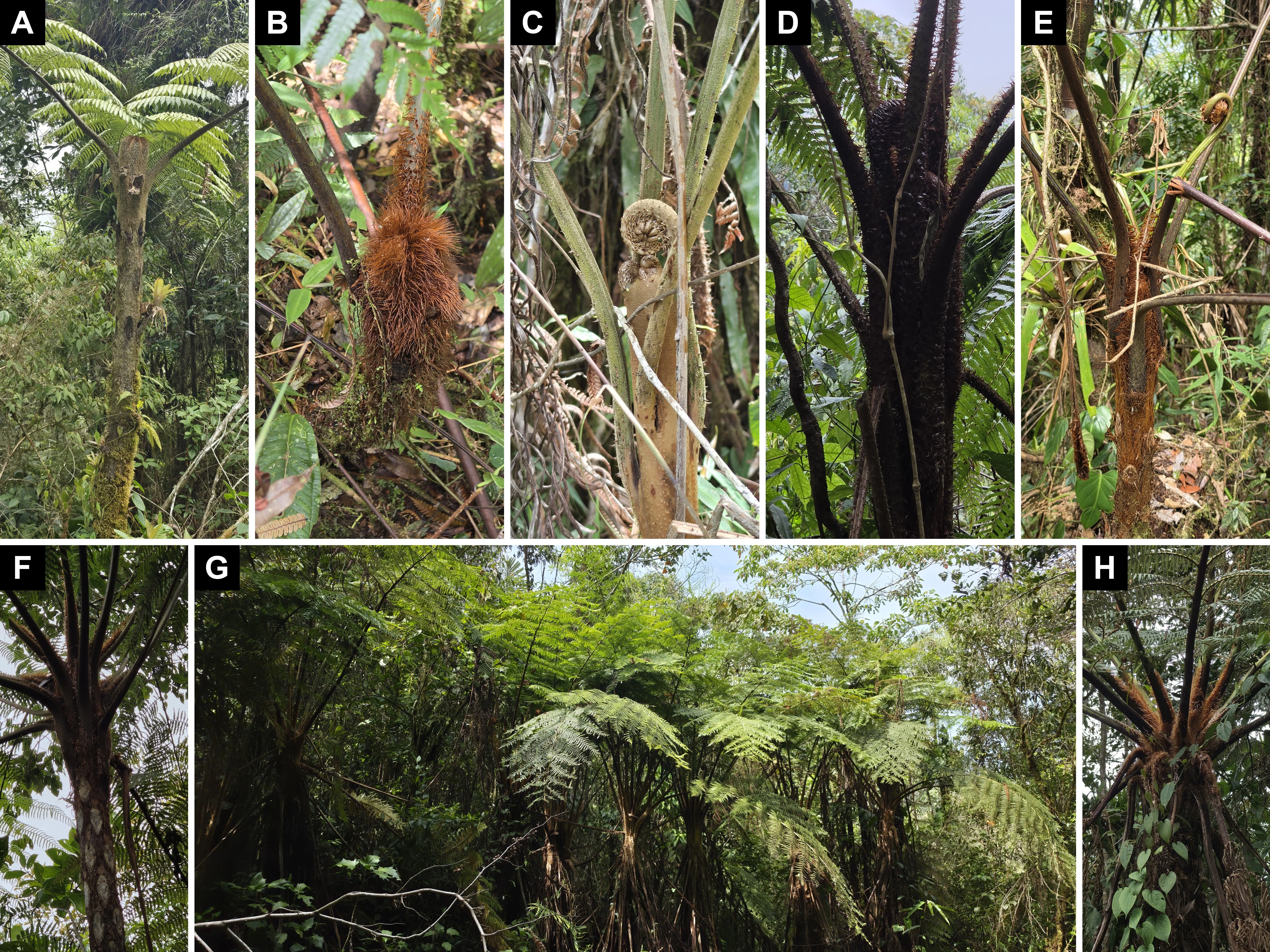
Thus at least Cyathea nigripes and C. planadae, and probably Sphaeropteris quindiuensis and Alsophila erinacea, occur both at Murringo and at La Honda, on slopes that appear largely forested in the satellite image (Figure 1). These shared species and this forest cover do not show that the habitat is equally suitable for Dicksonia, but at La Honda I have not found it. At least two explanations are possible.
The first concerns sampling. Montoya-López & Lehnert (2024) describe their method: free searches for Cyatheales along roads and trails, within a defined area and elevation band (1,967–2,600 m), with georeferencing and photographs of the diagnostic structures, and without voucher specimens. They do not, however, report the hours, distance covered or number of observers, and the design does not allow the probability of detecting each species to be estimated. Moreover, the tree fern collections of HUA and JAUM are scarcely represented in GBIF, and the HUA database has no Dicksonia from eastern Antioquia (HUA, 2026); the only eastern sheet I found is at JAUM and does not appear in GBIF. Even so, I do not think that Dicksonia has gone unnoticed at La Honda. It is a conspicuous tree fern, which I saw along the whole Murringo trail, and the 2024 inventory targeted Cyatheales specifically. Nor have I found it on my later visits, which include four days of free searches along roads and trails between 1,800 and 2,300 m in December 2024 and January 2025, with two observers, 6–8 h and 5–10 km per day (Montoya-López, 2025: 659). I therefore consider it more likely that the genus is absent from that band at La Honda. Without an estimate of the probability of detecting it, this is a hypothesis rather than evidence of absence. In the Reserva Natural La Planada (Nariño), on the Pacific slope at 1,850–2,300 m and with about 4,500 mm of rain a year, Dicksonia (as “D. sellowiana”, of uncertain present-day identity) occurred in all ten open-habitat plots, laid out in three abandoned pastures, where it made up 19% of the tree ferns counted, sporelings included; in secondary and primary forest it made up about 1% and occurred in only half of the plots (Arens & Sánchez Baracaldo, 1998: 61–62, 64, 66, 71). If it behaved the same way here, searches along roads and trails, which pass through open habitats and forest edges, would have had a good chance of finding it, as on the Murringo trail. But a roadside is not an abandoned pasture, and isolated plants inside closed forest could have escaped me.
The second is historical. In the La Honda area there was substantial harvesting of sarro, as a substrate and as a building material, and extensive clearing for pasture. Dicksonia karsteniana is one of the species that have been used as sarro (Cárdenas et al., 2019: 183), and the 1977 ban was issued because of the use of these ferns to make plant pots and handicrafts and in rural construction (INDERENA, 1977). Extracting Dicksonia sarro means sacrificing adult plants by cutting off their root system, which has reduced natural populations (Ramírez-Valencia et al., 2009: 18–19, citing Constantino et al., 1999). In the Reserva Forestal Protectora de Río Blanco (Manizales), in forest at an advanced successional stage, stem height growth measured on nine plants was 6.7 cm over 11 months, and only plants taller than 4 m were fertile (Ramírez-Valencia et al., 2009: 22, 25). The authors call them D. sellowiana, but an HUA specimen from Manizales, collected at 2,600 m and georeferenced about 0.6 km from the monitoring site, is determined as D. karsteniana (D. Sanín 1384, HUA; HUA, 2026). If that rate were general, a plant would take decades to reach fertile size, so removing the adults would remove the spore-producing plants for a long time. This is my own calculation, from eleven months of data at a single site, and the authors note that growth rate may vary with successional stage (Ramírez-Valencia et al., 2009: 23–24).
Judging by La Planada, clearing alone would not have eliminated it if fertile plants remained nearby. There, Dicksonia colonized abandoned pastures lying within 500 m of intact forest with tree ferns, and the authors assume that this proximity made spores readily available (Arens & Sánchez Baracaldo, 1998: 64, 68, 70). Stands with 30–40 years of regrowth there already had a tree fern composition very similar to that of the primary forest, which Cyathea planadae dominated (Arens & Sánchez Baracaldo, 1998: 66–67). If something similar happened at La Honda, the fact that Murringo and La Honda share several Cyatheaceae does not rule out that part of the La Honda forest was once cleared. One possible explanation is that sarro harvesting, together with clearing, removed the adult Dicksonia plants over a wide area and that, without nearby spore sources, the genus returned neither to the abandoned pastures nor to the regrown forest. Dicksonia would then have survived only around the Sonsón páramos (the 1999 Abejorral sheet lies about 11 km from the páramo delimited in 2016) and not in the forest that today appears continuous to the north, toward La Honda. This is my own inference: neither study deals with eastern Antioquia, the La Planada plants may belong to another species, and it remains to be explained why that history would have removed Dicksonia but not the Cyatheaceae that grow with it.
Murringo, however, is not the northernmost documented point of the genus in eastern Antioquia. The nearest record is the sheet from Abejorral (A. Gil et al. 376, JAUM 67933; HVAA, 2026), at 2,500 m, about 18 km north-west of the viewpoint and about 11 km farther north, although not in the direction of La Honda (Figure 1). It dates from 1999, and I do not know whether the population is still there. If the absence of Dicksonia at La Honda is real, it therefore does not mark a limit in latitude. The nearest of the specimens cited by Noben et al. (2018) lies to the south: D. karsteniana var. karsteniana in the corregimiento of San Félix (Salamina, Caldas), at 2,945 m, about 38 km south-southwest of the viewpoint according to the coordinates they publish (D. Sanín 3436, HUA, FAUC; Noben et al., 2018: 849). Farther away are the D. karsteniana var. karsteniana specimen from Envigado, at 2,550 m (F. Giraldo & S. Mejía 1899; Noben et al., 2018: 849), about 54 km away; the D. navarrensis specimen from Medellín, Paraje Boquerón, at 2,200 m (J. Hernández et al. 519; Noben et al., 2018: 853), about 63 km away; and the georeferenced GBIF records in Neira (Caldas) and Jardín (Antioquia), about 67 km away (GBIF.org, 2026a). At Jardín, Noben et al. (2018: 849) cite D. karsteniana var. karsteniana at 2,560 and 2,870 m.
Conservation
All Dicksonia in Colombia are under a ban (veda). INDERENA Resolución 0801 de 1977 declared the tree fern called “helecho macho”, “palma boba” or “palma de helecho”, of the families Cyatheaceae and Dicksoniaceae, a protected plant, naming Dicksonia among its genera, and established a permanent nationwide ban on its harvesting and trade (INDERENA, 1977). The resolution referred to the use of the root to make plant pots and handicrafts, mainly for export, and of the trunk in rural construction.
The ban is still in force. Resolución 0126 de 2024, which sets the official list of threatened species, does not repeal existing bans (MADS, 2024: art. 6). CORNARE, the environmental authority for Sonsón, includes it in Acuerdo 404 de 2020 among the bans it declares strictly binding at the national, regional and local levels (CORNARE, 2020: art. 3). In addition, the populations of Dicksonia in the Americas are listed in CITES Appendix II, with annotation #4, in the Appendices valid from 5 March 2026 (Cárdenas et al., 2019: 18; UNEP-WCMC, 2026).
Neither of the two candidate species is listed as threatened in Colombia, and neither appears in the global IUCN Red List, according to the copy published in GBIF that I consulted on 2 October 2026 (IUCN, 2026). The official list includes only D. lehnertiana (EN) and D. stuebelii (CR) (MADS, 2024). The Red Book of tree ferns assessed D. karsteniana and D. navarrensis at the national level as Least Concern (Cárdenas et al., 2019: 32, 193). Dicksonia karsteniana is one of the three species popularly used as “sarro”; according to the book, the bans achieved their purpose, because sarro is no longer offered in local markets as it once was (Cárdenas et al., 2019: 183).
As noted in the description of the trail, the viewpoint lies within the DRMI Páramo de Vida Maitamá–Sonsón and the bridge practically on its boundary. The DRMI management plan does not mention tree ferns (CORNARE, 2021).
Acknowledgements
I thank María Josefita Alcibíades, who guides the way and finds the ferns. The images of the JAUM sheets in Figures 4 and 5 come from the HVAA portal (HVAA, 2026). The photos in Figure 6 are by Jonatan Castro Hernández and are reproduced, cropped and assembled, under his CC BY licence (Castro Hernández, 2022).
References
Alzate FA, Sarrazola H, 2025. Estudios bióticos: Plantas, edafofauna epígea, anfibios y aves de los Complejos de Páramos de Sonsón y Urrao. Version 1.1. Instituto de Investigación de Recursos Biológicos Alexander von Humboldt. Occurrence dataset. https://doi.org/10.15472/wiu5hg
Arens NC, Sánchez Baracaldo P, 1998. Distribution of tree ferns (Cyatheaceae) across the successional mosaic in an Andean cloud forest, Nariño, Colombia. American Fern Journal 88 (2): 60–71. https://doi.org/10.2307/1547225
Arroyave Arrubla SI, 2017. Formación experiencial de paisajes campesinos. Río Verde de los Montes, Antioquia, Colombia. 1950-2016. Master's thesis in Human Geography. El Colegio de Michoacán, Centro de Estudios en Geografía Humana, La Piedad, Michoacán, Mexico.
Cárdenas D, Rodríguez W, García N, Sua S, Lehnert M, Giraldo F, 2019. Libro rojo de plantas de Colombia. Volumen 7: Helechos arborescentes. Serie Libros Rojos de Especies Amenazadas de Colombia. Instituto Amazónico de Investigaciones Científicas SINCHI, Ministerio de Ambiente y Desarrollo Sostenible, Bogotá.
Castro Hernández J, 2022. Dicksonia navarrensis, Pueblo Rico, Risaralda, Colombia, 5 February 2022. iNaturalist, observation 339463561. https://www.inaturalist.org/observations/339463561 (accessed 1 October 2026).
CORNARE [Corporación Autónoma Regional de las Cuencas de los Ríos Negro y Nare], 2016. Reserva Forestal Protectora Regional de los Cañones de los Ríos Melcocho y Santo Domingo: plan de manejo. Convenio Marco 112-2015, Nature and Culture International–CORNARE. CORNARE, El Santuario, Antioquia. https://www.cornare.gov.co/SIAR/Plan-de-manejo/plan-de-manejo-melcocho-santo-domingo/Plan-de-Manejo-de-los-Canones-de-los-rios-Melcocho-y-Santo-Domingo.pdf
CORNARE [Corporación Autónoma Regional de las Cuencas de los Ríos Negro y Nare], 2019. Acuerdo 388 del 6 de junio de 2019, por medio del cual se declara, delimita y alindera, el Distrito Regional de Manejo Integrado Páramo de Vida Maitamá–Sonsón y se dictan otras disposiciones. El Santuario, Antioquia. https://www.cornare.gov.co/Acuerdos/Acuerdo_388_de_2019_cornare.PDF
CORNARE [Corporación Autónoma Regional de las Cuencas de los Ríos Negro y Nare], 2020. Acuerdo 404 del 29 de mayo de 2020, por el cual se declara la veda para algunas especies de flora silvestre, en la jurisdicción de CORNARE y se toman otras determinaciones. El Santuario, Antioquia. https://www.cornare.gov.co/Acuerdos/Acuerdo_404_2020_cornare.pdf
CORNARE [Corporación Autónoma Regional de las Cuencas de los Ríos Negro y Nare], 2021. Plan de Manejo del Distrito Regional de Manejo Integrado Páramo de Vida Maitamá–Sonsón. CORNARE, El Santuario, Antioquia. https://www.cornare.gov.co/SIAR/Plan-de-manejo/DRMI-Paramo-de-Vida-Maitama-Sonson/Plan-de-Manejo-DRMI-Paramo-de-Vida-Maitama-Sonson.pdf
ESA [European Space Agency], Airbus, 2022. Copernicus DEM. GLO-30 instance (COP-DEM_GLO-30-DGED). European Space Agency. https://doi.org/10.5270/ESA-c5d3d65. Distributed by Microsoft Planetary Computer, collection cop-dem-glo-30. https://planetarycomputer.microsoft.com/dataset/cop-dem-glo-30 (accessed 30 September 2026).
García Morera Y, Bedoya A, Posada E, Atehortua A, 2018. Inventario de Flora de la Reserva Forestal Protectora Regional Cuchillas del Tigre, El Calón y La Osa. Municipios de San Francisco y Sonsón-Antioquia. Version 1.0. Corporación Autónoma Regional de las Cuencas de los Ríos Negro y Nare (CORNARE). Sampling event dataset. https://doi.org/10.15472/pkjb1p (accessed 30 September 2026).
GBIF.org, 2026a. Occurrence search for Dicksoniaceae in Colombia. https://www.gbif.org/occurrence/search?taxon_key=6622&country=CO (accessed 30 September 2026).
HUA [Herbario Universidad de Antioquia], 2026. Specimen query, genus Dicksonia. Universidad de Antioquia, Medellín. http://www2.udea.edu.co/herbario/paginas/consultas/consultarEjemplares.iface (export of 1 October 2026: 147 records from 59 collections, counted by collector and field number).
HVAA, 2026. Images of sheets JAUM 034577 and 034578 (F. Giraldo & S. Mejía 1907), JAUM 035210 and 035212 (F. Giraldo & S. Mejía 2035) and JAUM 67933 (A. Gil et al. 376), Jardín Botánico de Medellín Joaquín Antonio Uribe; search “Dicksonia, Colombia”, 219 records. HVAA Portal, herbariovaa.org (accessed 1 and 2 October 2026).
iNaturalist, 2026. Observations of Dicksonia (taxon 125929) and Dicksoniaceae (taxon 64674) in eastern Antioquia, retrieved through the iNaturalist API (https://api.inaturalist.org/v1/observations) within the box 5.3–6.6° N, 74.5–75.75° W and assigned to municipalities with geoBoundaries limits; for Sonsón, observations 319578300, 338031863, 338508364, 339784541 and 343521376 (accessed 2 October 2026).
INDERENA [Instituto Nacional de los Recursos Naturales Renovables y del Ambiente], 1977. Resolución 0801 del 24 de junio de 1977, por la cual se declara planta protegida una especie de flora silvestre y se establece una veda. https://faolex.fao.org/docs/pdf/col29080.pdf
IUCN [International Union for Conservation of Nature], 2026. The IUCN Red List of Threatened Species. Checklist dataset published in GBIF. https://doi.org/10.15468/0qnb58 (accessed via GBIF.org on 2 October 2026).
Jiménez Gómez AF, 2017. Criando la montaña, el agua y la vida: procesos hidrocomunitarios campesinos y acumulación por despojo hídrico en el Complejo de Páramos de Sonsón en Antioquia. Master's thesis in Sustainable Water Management. El Colegio de San Luis, San Luis Potosí, Mexico.
MADS [Ministerio de Ambiente y Desarrollo Sostenible], 2016. Resolución 0493 del 22 de marzo de 2016, por medio de la cual se delimita el Páramo Sonsón y se adoptan otras determinaciones. Bogotá. Layer of delimited páramos, scale 1:25,000, Minambiente: https://geo.minambiente.gov.co/server/rest/services/Ecosistemas_estrategicos_figuras_distincion/MapServer/2 (accessed 28 September 2026).
MADS [Ministerio de Ambiente y Desarrollo Sostenible], 2024. Resolución 0126 del 6 de febrero de 2024, por la cual se establece el listado oficial de las especies silvestres amenazadas de la diversidad biológica colombiana continental y marino costera, se actualiza el Comité Coordinador de Categorización de las Especies Silvestres Amenazadas en el territorio nacional y se dictan otras disposiciones. Bogotá.
Montoya-López A, 2025. Hidden in the Andes: new insights into the distribution of Magnolia guatapensis (Lozano) Govaerts (Magnoliaceae) and Cyathea antioquensis A. Rojas (Cyatheaceae). Check List 21 (4): 658–665. https://doi.org/10.15560/21.4.658
Montoya-López A, Lehnert M, 2024. Species richness of Cyatheales in the upper Santo Domingo Canyon, Antioquia, Colombia. Check List 20 (5): 1182–1191. https://doi.org/10.15560/20.5.1182
Noben S, Kessler M, Weigand A, Tejedor A, Rodríguez Duque WD, Giraldo Gallego LF, Lehnert M, 2018. A taxonomic and biogeographic reappraisal of the genus Dicksonia (Dicksoniaceae) in the Neotropics. Systematic Botany 43 (4): 839–857. https://doi.org/10.1600/036364418X697634
PNNC [Parques Nacionales Naturales de Colombia], 2026. Registro Único Nacional de Áreas Protegidas (RUNAP): Distrito Regional de Manejo Integrado Páramo de Vida Maitamá - Sonsón, area 1513 (1:25,000 polygon supplied by CORNARE). https://runap.parquesnacionales.gov.co/area-protegida/1513 (accessed 2 October 2026).
Pteridoportal, 2026. Specimen BRIT1135268 (sheets 2 and 3: BRIT1135269 and BRIT1135270), J. Castro-Hernández et al. 1819, Dicksonia navarrensis, Pueblo Rico, Risaralda, Colombia. https://pteridoportal.org/portal/collections/individual/index.php?occid=5573553 (accessed 1 October 2026).
Ramírez-Valencia V, Sanín D, Álvarez-Mejía LM, 2009. Estimación del crecimiento de Dicksonia sellowiana Hook., (Dicksoniaceae Hook.), en la Reserva Forestal Protectora de Río Blanco, Manizales, Caldas, y registros colombianos de su fertilidad. Boletín Científico. Centro de Museos. Museo de Historia Natural 13 (1): 17–29. http://www.scielo.org.co/scielo.php?pid=S0123-30682009000100002&script=sci_arttext
UNEP-WCMC, 2026. Species+: Dicksonia spp., listing in the CITES Appendices (taxon concept 13237; Appendices valid from 5 March 2026). https://speciesplus.net/species#/taxon_concepts/13237/legal (accessed 30 September and 2 October 2026).